

Andorra is renowned for its distinctive and scenic via ferratas in the Pyrenees, offering free access to all.
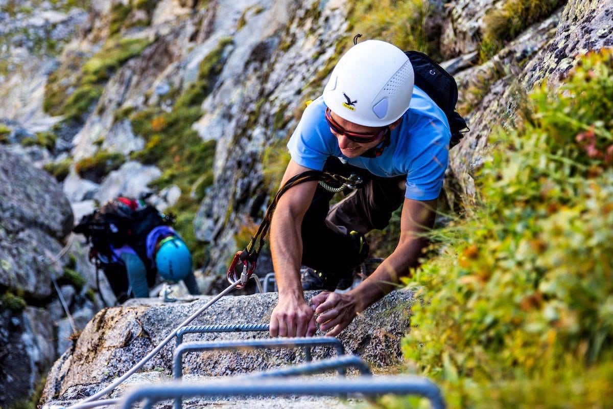
Via ferrata is a hybrid activity combining elements of rock climbing and mountaineering. It comprises a series of man-made and natural challenges designed to increase safety on a climbing route.
These enhanced paths enable climbers to navigate landscapes that would otherwise be extremely difficult to tackle. Adding to the adventure, some routes have no traditional exits, requiring abseiling as the sole method of descent.
This article will explore our top picks for via ferratas in Andorra.
Andorran Via Ferrata Itineraries
Via ferrata or iron routes in Andorra range from 150 to 400 metres in length and from K1 to K5 in terms of difficulty on the Hüsler scale. If you’re new to this sport, it’s worth noting that it will test you physically and mentally. Anything over K2 is recommended for people with prior climbing experience.
That said, K1 and K2 via feratas are quite approachable; as long as you’re physically fit and know how to climb a ladder, you’ll easily tackle these. Here are some of our top recommendations.
Tossal Gran d’Aixovall

Difficulty: K1
Descent duration: 25min
Climb duration: 1h 25min
Length: 150 m
Elevation gain: 40 m
Location: Aixovall
Summit altitude: 990 m
Orientation: East-facing
GPS coordinates: 42° 28′ 44″,01° 29′ 19″
The Tossal Gran via ferrata, situated near the village of Aixovall in Sant Julià de Lòria is classified as a moderately difficult route.
It lies at the base of the La Valira River and ascends the walls of Tossal Gran. Climbers particularly enjoy the challenging sections and athletic overhangs.
Sant Vicenç d’Enclar

Difficulty: K3
Descent duration: 40min
Climb duration: 2h
Length: 270 m
Elevation gain: 190 m
Location: Andorra la Vella
Summit altitude: 1,190 m
Orientation: East-facing
GPS coordinates: 42° 29′ 46″,01° 29′ 47″
Tucked away on the road leading to the Sant Vicenç d’Enclar church in Santa Coloma, this via ferrata is a great way to indulge in cultural tourism.
It presents a medium level of difficulty. On the approach, visitors will encounter the 12th-century hermitage of Sant Vicenç d’Enclar, after which the demanding route passes through a holm oak forest flanked by steep cliffs.
Getting to the via ferrata involves travelling to the end of Carrer dels Barrers in Santa Coloma, where a small parking area is available.
Roc d’Esquers

Difficulty: K3
Descent duration: 1h 40min
Climb duration: 3h 50min
Length: 350 m
Elevation gain: 250 m
Location: Escaldes
Summit altitude: 1,780 m
Orientation: Southwest-facing
GPS coordinates: 42° 30′ 17″,01° 33′ 08″
The Roc d’Esquers via ferrata is situated on the Entremesaïgues trail at the Madriu Valley’s entrance in Escaldes-Engordany.
With a medium level of difficulty, it’s a favourite among alpine enthusiasts. It boasts exceptional vertical passages and comprehensive elements, characteristic of Andorra’s via ferratas.
It’s challenging enough not to bore even the most experienced hikers all without being overly exposed. There’s a nice, quaint little Tibetan bridge towards its conclusion.
Clots de l’Aspra

Difficulty: K1
Descent duration: 25 min
Climb duration: 1h 45min
Length: 150 m
Elevation gain: 70 m
Location: Encamp
Summit altitude: 2,200 m
Orientation: Northeast-facing
GPS coordinates: 42° 32′ 05″,01° 37′ 57″
The Clots de l’Aspra via ferrata, situated in Cortals d’Encamp, is among the easiest routes you’ll come across in Andorra’s alpine circuit.
Designed as an introductory via ferrata for children, the Clots de l’Aspra features an initial section that ascends a sloping overhang equipped with numerous steps to facilitate easy climbing.
Canal de la Mora (I & II)

Difficulty: K2
Descent duration: 25 min
Climb duration: 1h 35min
Length: 400 m
Elevation gain: 200 m
Location: Canillo
Summit altitude: 1,700 m
Orientation: Southeast-facing
GPS coordinates: 42° 34′ 02″,01° 35′ 40″
The Mora Canal begins at Coll d’Ordino in the parish of Canillo and offers two distinct routes: Canal de Mora I and II. Number 1 is encased in the Mora Canal while the other involves walking up to the Roc de Quer viewpoint.
Seasonal changes may present either water or ice along the way. This can be avoided by taking the 2nd route on the right since it’s more vertical and avoids the riverbed entirely. It’s worth noting that this via ferrata has no escape routes, so you’ve got to go back the way you came.
Roc del Quer

Difficulty: K4
Descent duration: 40 min
Climb duration: 2h 55min
Length: 500 m
Elevation gain: 350 m
Location: Canillo
Summit altitude: 1,920 m
Orientation: Southeast-facing
GPS coordinates: 42° 34′ 01″,01° 35′ 37″
Roc de Quer is a prominent stone wall that dominates the entrance to Canillo from Escaldes-Engordany. Here’s where the aerial via ferrata is situated; it ascends the wall’s centre without any detours and boasts a flanked midway.
You’ll find many attractions and interesting features here, including a panoramic view of Canillo and a very exposed but exciting overhang.
Racons

Difficulty: K4
Descent duration: 40 min
Climb duration: 2h 25 min
Length: 400 m
Elevation gain: 210 m
Location: Canillo
GPS coordinates: 42°33.966’N 001°35.825’E
Located in Roc del Quer, the Racons via ferrata is a short distance from the town of Canillo. Since the route is notably vertical and presents a striking challenge, it’s intended solely for expert climbers. That said, it serves as an excellent initiation into climbing.
It features ascent points with numerous steps and overhanging wall sections that demand sustained effort until the very end. It’s worth noting that the route does not have emergency exits.
Canal del Grau

Difficulty: K3
Descent duration: 15 minutes
Climb duration: 1h 30min
Length: 350 m
Elevation gain: 90 m
Location: Canillo
Summit altitude: 1,745 m
Orientation: Southeast
GPS coordinates: 42° 33′ 50″,01° 35′ 13″
The Canal de Grau route is distinguished by its predominantly horizontal trajectory, featuring suspension bridges and the ascent of the unique Agulla Vermella.
It’s one of the most entertaining and imaginatively put-together via ferratas in the country and is commonly thought of as a continuation of the Racons route.
Collada Dels Isards: De L’esquerra & de la Dreta

Difficulty: K1
Descent duration: 1h
Climb duration: 2h 10min
Length: 70 m
Elevation gain: 50 m
Location: Pas de la Casa
Summit altitude: 2,700 m
GPS coordinates: 42° 31′ 15″,01° 43′ 45″
The Coll dels Isards via ferrata, situated near Pas de la Casa, offers two routes: the right and left slopes. Both are integral to the “Coll dels Isards” via ferrata, starting and finishing at the same location.
De l’esquerra, the right slope, presents a greater challenge, requiring good technique despite its K1 difficulty classification. Starting at 2,153 metres and peaking at 2,700 metres, it’s classified as a high mountain via ferrata.
At the summit, you’ll be rewarded with breathtaking panoramic views of the valley. When heading back, you can ascend the right slope and descend the left, or the reverse. Alternatively, you can extend the excursion by connecting with another nearby via ferrata.
Note that the approach involves a lengthy hour-long trek ascending 400 meters.
Roc de la Coma d’Erts

Difficulty: K2
Descent duration: 35min
Climb duration: 2h
Length: 435 m
Elevation gain: 200 m
Location: Erts
Summit altitude: 1,650 m
Orientation: Southwest-facing
GPS coordinates: 42° 33′ 42″,01° 29′ 70″
The Roc de la Coma d’Erts via ferrata is located in the village of Erts, within the parish of La Massana. It features athletic aerial sections and overhangs across an extensive stretch secured with chains.
Expect off-camber sections tilting to the left, vertical ledges bolstered with staples, and breathtaking views from the peak at an altitude of 1,650 meters.
Roc del Gos

Difficulty: K4+ la mas dificil
Descent duration: 25 min
Climb duration: 1h 15min
Length: 120 m
Elevation gain: 100 m
Location: Canillo
GPS coordinates: 42° 34′ 04″N, 01° 35′ 44″E
The Roc del Gos via ferrata is situated along Montaup Road in the Canillo parish. Spanning 120 meters in length with a 100-meter incline, it demands a high level of expertise due to its extreme difficulty.
To access this via ferrata, follow the initial communal route of the Canals de la Mora 1 and 2 until you reach the narrowest section around the starting point of the 2nd Mora Canal, then take the path to the left.
During winter, it’s crucial to be well-equipped and exercise extreme caution as the route may present water, snow, or ice hazards. Additionally, for those looking to extend their adventure, there is an optional 85-meter abseil at the end: The Roc del Gos Abseil.
Via Ferrata: Mind Over Matter
To make the most of your via ferrata adventure and for optimal safety, you’re going to need the right kind of equipment. For instance:
- Helmet
- Climbing harness
- Y-shaped dynamic lanyard equipped with a zyper (shock absorber)
- Quick release carabiner
- Gloves
- Climbing rope
Many shops in Andorra sell this gear; €40 should buy you a decent kit (helmet and harness not included). The better your equipment is, the safer you’ll be; you don’t want to be faffing around with a dodgy carabiner at a crucial juncture.
If you’re new to this, it helps to know that doing via ferrata well is a case of mind over matter. As long as you possess basic fitness and aren’t afraid of heights, you can pull it off and look back at your achievement with pride.